Thursday, May 19, 2016

Making the Cut: The Yesler Mill on Union Bay

On New Year’s Day, 1890, The Seattle Post-Intelligencer published an article touting the benefits of purchasing property at Ravenna Park, north of the city limits. To bolster the argument, the article pointed to the settlement of Yesler as a neighboring thriving community:

“Yesler Mill, a settlement of some sixty houses, with ice factory, church and stores -- just a little east from the Park -- is doing a flourishing business and affords us lumber at $1 per thousand [board feet] cheaper than other mills.”

Since the town of Yesler had only been platted two years earlier, it seems doubtful that all “sixty houses,” church, and stores were in evidence.

The community which would be variously known as the Town of Yesler, Yesler Mill, Yesler Junction, or simply Yesler -- was laid out in 1888 as something like a company town to support Henry Yesler’s second mill on the north shore of Union Bay. The town father himself passed away in 1892 and had little to do with the mill operations.

[For an expanded version of this essay, including details on the town and its institutions, see the blogpost Mill Village.]

The Yesler Mill was built on the north shore of Union Bay on Lake Washington on the property that is now the University of Washington’s Urban Horticulture Center and the adjacent Yesler Swamp, west of Laurelhurst. Equipment was probably transferred to the location from the original Yesler Mill in Seattle which had burned down in 1887.


Men, women, and a child atop logs at the Yesler Mill on Union Bay. Photo dated 1892?, Courtesy of Seattle Public Library. 


Soon after the mill was established a spur railroad line was put in to connect the mill to the Seattle, Lake Shore and Eastern Railway line, now the Burke Gilman Trail. Maps of the day are not always reliable; however, we see the railway spur on maps from 1890 (O.P. Anderson and Co., Seattle and Environs) and 1895 (Seattle and Lake Washington Waterway Company, Guide Map to Seattle), but the Baist Maps, beginning in 1905, show no spur. The apparent loss of direct rail transportation for lumber up to the main line is one indication that things did not always run smoothly at Yesler Mill.


Baist Map, 1908, UW Special Collections. This map demonstrates how, prior to the cutting of the ship canal, the waters of Union Bay lapped up to and across a portion of E. 41st at high tide.

FIRE AND ICE


This photo from the collection of the Seattle Public Library is undated, but was probably taken prior to the 1895 fire. The railroad is apparent in the background. What appears to be a small church appears at the far right hand. This may have been the Yesler Junction Church.

Fire was the enemy of all sawmills. A catastrophic fire of unknown cause devastated the mill in 1895, only seven years after it was established. A lengthy article in the Seattle Post-Intelligencer on September 17 of that year described the chaos:

“YESLER MILL BURNED. Devouring Flames consume the Plant and Lumber Yard. The Town Narrowly Escapes. Employes (sic] Can Do Nothing but Watch Mill and Lumber Burn.

The entire plant of the Yesler mill at the town of Yesler, on a spur of the Lake Shore road, was destroyed by fire last night, together with nearly the whole stock of lumber, the wharf and eight cars of the lake Shore road. The fire burned so fiercely that the flames were visible throughout the city and for miles around and it was thought that the whole town of Yesler had been destroyed….Fire was discovered at 11 o’clock by the night watchman in the dry kiln. The watchman blew the whistle and in a few minutes a large crowd had gathered, but the fire spread with wonderful rapidity, and in a few minutes the entire mill was in flames."

The reporters on the scene were able to give a rip-roaring first person account of the conflagration:

“About this time a wind from the south sprang up, driving the men away from the lumber back among the houses on the hill. The timbers began to fall and broke the water pipe, leaving the men helpless. The flames at this point were leaping into the air full seventy-five feet and the heat was terrific. Standing on the tracks were six logging cars and two box cars belonging to the Lake Shore road, two of which were loaded ready to ship East: one had logs aboard and the others were empty. As the flooring timbers were burned away these eight cars crashed down into the lake. About the same time the boilers and engine were heard to fall.
In about thirty minutes there was nothing left of the mill but a few smoking timbers. The fire confined itself then to the immense piles of lumber, and gradually ate it way toward the office.
So rapid was the progress of the fire that one of the men, H. Butler, at work on the wharf was cut off from escape and had to jump into the water. He seized a boom chain and hung on until he was rescued.” (p. 2)
The report goes on to relate how the fire eventually burned itself out “chiefly for lack of further food,” and how water from the neighboring ice plant saved some lumber piles and the mill post office building.

Reporting in the days following the fire focused on the untangling of insurance claims and the burning question: would the mill be rebuilt?

It is clear from the newspaper accounts that there was more than one going concern on the mill property at the time of the fire. This was not a company town in the traditional sense. Portions of the mill property were leased to the Great Western Lumber and Supply Company while the ice company also appeared to be an independent entity. Other claims were less clear: “There appears to be some doubt as to the proprietorship of the wharf and dock burned, and it will probably be some days before a full adjustment of the losses can be reached.” (Seattle P-I, September 18, 1895, p.8) 

A bulletin in the same paper three weeks later reports that “A.H Ruelle, of Ruelle Bros, lessees of the Yesler mill, at Yesler, recently destroyed by fire, is now in the East closing accounts of the firm. He expects to make arrangements before his return to erect a new mill, probably on the site of the old.” (Seattle P-I, October 6, 1895, p. 8.)

The receivers of the Lake Shore and Eastern Railway also suffered losses, as described in the P-I article of September 18, 1895. In addition to the train cars lost it is likely that a good portion of the spur line was damaged or destroyed. Since the spur line disappears from maps soon after this date, one might conclude that the line was never rebuilt.

THE ICE PLANT


Various sources refer to the Seattle Ice Company, Union Ice Company, or Lake Union Ice Company sharing quarters with the Yesler Mill. In the days before home refrigeration, companies that delivered blocks of ice to your door were an indispensable part of the community.

A section of the Sanborn Fire Insurance map for 1893, two years before the fire, shows several structures of the Union Ice Company, including freezing tanks, ice storage, and oil storage.
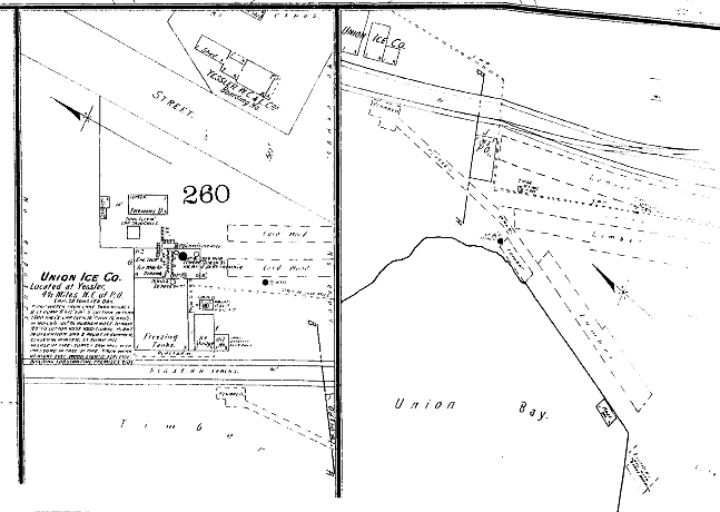

The Sanborn map provides intimate details of the workings of the ice company. It had the capacity to produce 20 tons of ice per day, pumping water directly from Lake Washington into 7500 gallon tanks, 16 feet tall. The plant was in operation day and night in summer; closed in the winter. Being a fire map, Sanborn goes on to tell us, somewhat prophetically, “The station pump [will] supply sawmill with pressure in case of fire.” The Sanborn notes conclude that the building is “substantial, premises tidy.” (Sanborn Fire Insurance Maps, Seattle, 1893, Vol. 2, Sheet 55a)

This small snippet of map may be the best depiction we have of the mill property in the few years it was active before the 1895 conflagration. The diagram also shows the route of the railroad spur, a “Yessler [sic] W. C. & L. Co. boarding hotel,” lumber runs, planked roadbeds, and a combination office and post office.

The lengthy article describing the fire in the P-I also gives a snapshot look at operations at the mill:

“[The mill] had a capacity of 75,000 feet in 12 hours and employs 36 men. It was a two-story structure with the sawmill on the upper floor and planing mill and engine room on the lower floor. It contained two double circular saws, an Allis edger, two large wood planers, a sticker, a shingle machine and a lath machine, a Corliss engine and a Noyle engine, two large boilers, an Allis steam setwork with twin engine…Of the 1,000,000 feet of lumber in the yard, only 15,000 to 20,000 was saved.

DECADES OF CHANGE


The years between 1895 and 1912 are somewhat hazy. All sources agree that at some point a shingle mill was constructed on the property that was the Yesler Mill. In her history of Laurelhurst, Christine Barrett reports that folks used to set their watches by the mill's noon and four o'clock whistles. 

One encounters the term “Yesler Mill” in newspaper articles and on maps as late as 1918. Whether the mill was operated by the Yesler Logging Company or an affiliate during this period is not clear. It is possible that the term “Yesler Mill” was just a comfortable moniker.

Beginning in 1912 the researcher finds references to a Two Lakes Mill which manufactured shingles at Yesler Station and maintained an office in the downtown Henry Building. Articles of Incorporation for the Two Lakes Mill were filed August 24, 1912. Newspaper ads include the following:

“Wanted: shingle bolts and stumpage near Lake Washington at once. Two Lakes Mill Co.” (1912)

“Wanted: to let contract for hauling several hundred cords shingle bolts, Two Lakes Mill Co.” (1913)

“Shingle your house all over with shingles made in Seattle. Inquire about our four grades and prices. Two Lakes Mill Co.” (1916)

The 1918 Polk City Directory contains a bolded listing for Two Lakes Mill: “Mnfrs of High Grade Premium Red Cedar Shingles.” However, the very next year the listing had been reduced to two words -- “wholesale shingles” -- perhaps indicating a downturn in the business.

Any doubt that we are talking about the same property where the Yesler Mill stood is laid to rest by an annotated diagram in the Sanborn Fire Insurance Map for 1919 showing the workings of “Union Bay Shingle Co./Two Lakes Mill Co’s Shingle Mill.” Notes on the diagram indicate that the mill had a capacity of 105,000 shingles in eight hours, that there was a night watchman, and that water was taken from Union Bay.


The question of corporate names does not die easily. In 1917, The University District Herald, under the headline “Yesler Mill Running,” reported “This mill has been idle for some time and it is indeed good to see the wheels turning again. It furnishes work for a bunch of men who are causing their earning to benefit Yesler in general.” (July 27, 1917) On April 25, 1918, The Seattle Daily Times reported that a shed had been destroyed by fire at the Yesler Mill Company plant, but that the mill itself was saved by the fire department.

The mill may have dodged this bullet in 1918, but most sources agree that the mill buildings succumbed to fire sometime in the 1920s. (Thompson, Barrett) There would be no rebuilding this time. It is likely that the cutting of the Lake Washington Ship Canal in 1916, and the subsequent lowering of Lake Washington, made it just that much harder to run a lumber mill of any kind.

As the lake waters receded, they left the mill wharf high and somewhat dry and the mill pond only slightly damp. At some point an attempt was made to dredge a channel into the bay in order to make the mill run viable again. This last ditch effort must have had only limited success because by the mid-1920s the mill was gone. Long-time resident Jim Thompson recalls watching the mill burn in 1928 or 1929.

While some lake mills may have benefited from access to the big steamers that the cut afforded, the Yesler Mill, on a shallow bay, was already too low in the water to make that leap. The mill's loss was the U Dub's gain. All the mill acreage, as well as most of the newly exposed wetlands at Union Bay, was acquired by the university with new uses in mind.


MEMORIES OF YOUTH


In 1971 not-yet-famous author Ivan Doig wrote a piece for The Seattle Daily Times based on the recollections of his neighbor in the area known as Exposition Heights overlooking University Village shopping center. Bill Lozott, Doig’s informant, recalls going down to the dredged mill channel to swim after a hard day’s work in the mid-1920s. 

In 2010, Jim Thompson, shared memories with the Friends of the Yesler Swamp and in 2016 spoke with this author. Both Lozott and Thompson recalled sawdust piles on the old mill site that would smoke and occasionally combust on hot days. Thompson remembers that the mill run “was dug deep enough to accommodate a tug;” he and his pals kept a very small sailboat, “the tar baby,” in the mill run.

My friend John found this old boat in the swamp. At that time they were building 43rd NE. Part of what they were doing to build it -- they had tar. So John and I went up and secured the tar, brought it down, melted it, and used it to caulk the boat somewhat. It was just a little throwaway. About a 10 or 14 foot little sailboat. So we went sailing. I was in my very best clothes -- and we tipped over! So I’m swimming in a brand new suit of woolen clothes.I had to throw them away, of course.

The dredged mill run can be clearly seen about center in this aerial from 1937. Even after the mill closed, neighbors attempted to keep the run open for boat launches. The channel eventually was abandoned to the encroaching wetland now known as Yesler Swamp. Image Courtesy University of Washington Special Collections.

***


Sources include:

  • Guy Reed Ramsey, Postmarked Washington: King County, 1966.
  • Christine Barrett, A History Of Laurelhurst, 1981.
  • Lucile McDonald, The Lake Washington Story, 1979.
  • The website of the Friends of Yesler Swamp. http://yeslerswamp.org/history/
  • Valerie Bunn's blogspot: https://wedgwoodinseattlehistory.com/author/valariebunn/.
  • Various articles from The Seattle Times, The Seattle Post-Intelligencer, and The University District Herald, including: Ivan Doig, “The home-town boy,” Seattle [Daily]Times, April 18, 1971.
  • Special Collections, University of Washington, including historic maps collection
  • Puget Sound Regional Branch, Washington State Archives, property and corporate records. 
  • Memories of Jim Thompson, courtesy of Friends of the Yesler Swamp, 2010, and as told to Eleanor Boba, 2016


-- Eleanor Boba, 2016


Thursday, May 5, 2016

Ship Shapes: The Ed Monk Sr. Ships Plans Collection

Grant funding from King County 4Culture has allowed us to plunge into the daunting task of preserving and cataloging the remarkable Ed Monk Sr. collection of ships plans. In this essay we'll revisit the man with the plans.


Ed Monk Sr., circa 1967.


In 2014 Puget Sound Maritime Historical Society accepted a large collection of drawings, documents, photos, and artifacts related to the work of renowned naval architect Edwin Monk (1894-1973) from his family. Monk was a designer and builder of boats large and small, pleasure and commercial. His vessels are familiar to mariners all along the Pacific Coast. The collection is an invaluable resource to those fortunate enough to own a Monk-designed boat, as well as to all interested in the history of boat design. We would like to thank Ed Monk, Jr., son of the shipbuilder, for arranging the donation of this collection to PSMHS.


Ed Monk at his National Building Office, circa 1967

Edwin Monk began his career as a shipbuilding apprentice in 1914, working with his father who was a shipwright in the Puget Sound area. He built the first boat of his own design in the backyard of his Seattle home. While working at the Blanchard Boatyard on Lake Union, Monk had the opportunity to meet the legendary naval architect Ted Geary. In 1926 Geary hired Monk as a draftsman. When Geary decided to move closer to lucrative prospects in California, Monk joined him there, taking his young family to Long Beach for two years.

Around 1934 Monk returned to the Pacific Northwest and designed and built the 50-foot live-aboard cruiser Nan. Moored at the Seattle Yacht Club, the boat became both his office and home for his family for six years. A few years later he moved his work space into a small corner of the Grandy Boat Company and later to an office at on Westlake Avenue.

In 1947 Monk, joined by fellow naval architect Lorne Garden, moved to the National Building near Colman Dock. From here he commuted to his home at Hidden Cove on Bainbridge Island. After an illustrious career, Monk died in 1973 at the age of 79.


The Monk Collection includes over 2,000 individual vessel designs on over 7,000 pages. In addition we have been given several of Ed Monk’s half-hull ship models, his drafting curves, and his shop sign. His photograph collection, which chronicles the construction of his ships, is currently being cataloged for accession. 

Remembering the Man and his Boats

The acquisition of the Monk Collection inspired us to learn more about the man and his world. We conducted oral history interviews with his daughter, Isabel Van Valey, and with his niece-by-marriage and one-time secretary, Doris Colbert. These personal accounts supplement the great information in the book Ed Monk and the Tradition of Classic Boats by Bet Oliver (1998). Transcripts of the interviews may be viewed by arrangement at the PSMHS office.


Isabel Val Valey in her home overlooking Rich Passage.

Isabel Van Valey, Monk's daughter, recalls excursions on the Ann Saunders, the first boat Ed Monk built for himself.

The boat was a typical…I think what they call a dreamboat design…and it was kind of like a shoe, with a hull and a cabin that came up….It reminded you of a shoe. And the cockpit had a nice, big long seat on it, so we could sit on it. He was very, very cautious about us not falling overboard, and so when we went through the locks or there was any bad weather we were tied. It didn’t bother me at all, but it bothered my sister terribly. She was older and she would sit on the ropes, because she didn’t want anyone to see her. [laughs] The life jackets those days were just great big bulky pieces of cork, and this was much simpler for us.
Going through the locks was the most interesting. Mother would take the bow line and Dad would take the stern line because he was near the wheel, and we would have to sit in the back on our ropes. This lady once said, “Oh, look at those poor children tied up like dogs!” And my mother was very indignant and said “I’d rather have them tied like dogs than drowned!”
That was my earliest memory [of the boat], and I remember a big electric storm with thunder and lightning bolts while we were crossing in the boat. And I think that’s why I don’t like thunder and lightning now.

Monk's plan for a troller
Another memorable Monk boat was the Nan, the family's home for several years.

Well, it was a live-aboard. It was designed especially for us. My sister and I had a stateroom and my parents had the back stateroom and our living room was the pilot house, which eventually [had] an office in one corner. And the galley was down below on the bow. Mother didn’t like it down there because she couldn’t see where we were going or what we were doing, and I think that was one reason why Dad was inspired to move the galleys up to the pilot house.

Doris Colbert recalled working with Monk during World War II:

When I started to work for him he was called up by the army to make a trip up to Alaska to design flat-bottomed boats for the rivers up there because the United States government was putting in the Alcan [Alaskan-Canadian] Highway. And so they needed these flat bottomed boats to cross the rivers. This is what he designed. At that particular time it was mostly work for the government, but there were times when he did fishing boats, too, because we had to feed the troops and Seattle was a port of embarkation. 

Embarking on a Voyage of Preservation


The Monk plans, photos, and objects, while well organized, require proper archival storage and cataloging. It is a big job! UW Information School students Jodi Myers and Suzanne LeDoux have laid the groundwork for us by formally assessing the collection and estimating the resources (time, money, personnel) required to complete conservation. They also drafted a user guide for staff and volunteers working on the conservation project.


PSMHS volunteer John Kelly has helped curate the Puget Sound Maritime ships plans collections for years. 

Cultural resource specialist Katherine Kidwell has been working with PSMHS staff and volunteers since January of this year to place the ships plans into archivally safe storage and entering detailed information about each hand-drawn page into our PastPerfect database. A great deal of work remains to be done, but we are pleased to have set sail on this exciting voyage!


Katherine Kidwell shows us how the Monk ship plans are stored.

--John Kelly and Eleanor Boba contributed to this post. Special thanks to King County 4Culture for funding this important preservation project.


Monday, April 25, 2016

Making the Cut: The Locks by the Numbers

Puget Sound Maritime researcher Joe Baar gives us some insights into the monumental undertaking that was and is the Ballard Locks. This is one of an occasional series of essays commemorating the centennial of the Ballard Locks and the Ship Canal.


Early, undated photo of the "government locks," probably mid-1940s. Puget Sound Maritime Historical Society, Joe Williamson Collection, Negative # 2301-4.

Early Efforts

By 1854 a navigable connection between Lake Washington and Puget Sound to allow movement of logs, milled lumber, and fishing vessels between these bodies of water was being discussed sporadically. After the Civil War, in 1867 the U.S. Navy endorsed a canal project, which included the idea of constructing a naval shipyard on Lake Washington. In 1891 the U.S. Army Corps of Engineers began planning the project; some preliminary work occurred in 1906.

Legal challenges mounted by Ballard mill owners who feared property damage and loss of waterfront in Salmon Bay, and by Lake Washington property owners whose docks and waterfront would be left 9 feet in the air, delayed construction for another five years. Work finally began after midsummer 1911 under Major Hiram M. Chittenden’s command. All the delays in planning and construction finally caused the Navy to establish the Puget Sound Naval Shipyard across Puget Sound from Seattle, in Bremerton.

To facilitate expected maritime traffic, three low bridges and trestles crossing the ship canal route were removed, at Fremont Avenue, Stone Way and Latona Avenue. New bridges in Ballard and Fremont were completed in 1917, followed by University Bridge in 1919, and Montlake Bridge in 1925. University Bridge was improved in 1932, and in 1934 the Corps declared the Lake Washington Ship Canal project complete.


Dates, Size, Usage

Construction began on the Government Locks August 6, 1911. Both locks opened to traffic in the summer of 1916, the small lock on July 30 and the large lock on August 3. During those four years and eleven months the U.S. Army Corps of Engineers excavated 1,661,400 cubic yards of earth for the Salmon Bay locks and dam alone, then filled the resulting basin with 227,000 cubic yards of carefully-formed concrete.

The Corps reported Hiram Chittenden Locks hosted 1,300,000 visitors and conveyed 50,000 watercraft and 1,000,000 tons of commercial goods during 2013. As the price of oil declines, we can expect even greater volumes in all these categories.


Comparison with Modern Structures

Modern comparisons show the relative size of this undertaking. Forty-five years after the locks first carried traffic, the Seattle Space Needle’s foundation was completed in 1961 using continuous 24-hour concrete placement into a mass requiring 2,747 cubic yards of concrete. In 2015 the Amazon Complex’s Block 19 Mat Pour, the building’s foundation within the block bordered by 6th and 7th Avenues and Lenora and Blanchard Streets, required more than 12,000 cubic yards, which covered the excavation’s bottom more than 12 feet deep in concrete and reinforcing steel. The volume of concrete used to construct the Government Locks amounts to about 19 times what the Amazon Block 19 Mat Pour required, and is about 83 times what the Space Needle’s 5,600-ton foundation used.


The Cuts - Fremont

A continuous waterway extending from Puget Sound to Lake Washington requires two separate and sequential channels excavated through intervening landforms. Westernmost of these is the Fremont Cut, named for the Fremont neighborhood lying just across a swale north of Queen Anne Hill. In 1883 the Lake Washington Improvement Company contracted with the Wa Chong Company to provide immigrant Chinese labor to dig the Fremont Cut along the low-lying route of Lake Union’s outlet, Ross Creek, to Salmon Bay, which was tidal salt water until the Government Locks were in place. After excavating this section in 1885 the Wa Chong laborers moved on to complete the log sluice at the Montlake Portage, located near and beneath today’s State Route 520. All this work was accomplished solely by use of hand tools.

The Fremont Cut’s eastern end near Fremont Avenue was separated from Lake Union by a low wooden dam, a small wooden lock, and a spillway. The cut thus continued Ross Creek’s function as an overflow drain for Lake Union and Lake Washington until the Government Locks at Salmon Bay were finished in 1916, which caused the water level behind them to rise and meet that of Lake Union. Shortly afterward Lake Washington drained westward until all the fresh-water bodies’ elevations equalized.

The Fremont Cut is approximately 5,800 feet long. The maintained ship channel taking up the center section of this waterway is 100 feet wide and 30 feet deep; the cut’s entire width, bank to bank, is 270 feet. The total amount of material excavated for this cut is thus around 2,200,000 cubic yards.


The Montlake Cut in snow, looking east, showing the remnants of the coffer dam, circa 1916. Puget Sound Maritime Historical Society, Joe Williamson Collection, Negative #10345.


The Cuts - Montlake

The easternmost cut at Montlake was originally named the Erickson Cut, after the first contractor hired to excavate this section. The Corps’ Major C.W. Kutz awarded C.J. Erickson’s contract on August 7, 1909, and dry excavation proceeded from October that year until October 26, 1910, when the dike on the Union Bay end of the cut was dynamited, allowing water to fill it. Further hydraulic excavation by Stilwell Brothers continued until June, 1914, and temporary wood cofferdams replaced part of the earthen dikes at both ends of the Montlake Cut to allow control of its water level so work on the Montlake Bridge’s abutments and foundations could proceed. After the last bond issue funding this construction passed in 1915, the bridge’s foundations were finally begun.

On August 26, 1916 the Portage Bay cofferdam was removed, followed several days later by the one on the Union Bay end. Lake Washington’s level then descended 8 feet 10 inches over the following three months, and the Lake Washington Ship Canal gradually assumed its normal level from Lake Washington, through Lake Union, to the Government Locks.

The Montlake Cut is approximately 2,500 feet long. The maintained ship channel taking up the center section is 100 feet wide and 30 feet deep; the excavation’s entire width between the high points of each bank, is 350 feet. The total amount of material excavated for this cut is nearly 2,400,000 cubic yards.


Observations from Today

The entire span of time between Thomas Mercer’s discussions with his fellow-citizens about what the inland lakes should be named, until the Corps of Engineers declared the Lake Washington Ship Canal complete, amounted to eighty years. Today we look forward with great impatience to the promised completion of several major public works projects, also related to transportation, in the central Puget Sound region. We are not able to calculate the cost of this new infrastructure with any real certainty, and discovering how much the Lake Washington Ship Canal actually cost the citizens, beginning 162 years ago until all the financing bonds were retired, is a task beyond the scope of this short article. What we do know from our own experience is, it wasn’t cheap then and it won’t be cheap now. These great expenses provide immense known and imagined benefits to all citizens for a very long time to come. Public works of this scale animate our society now and help bring the promise of a bright future for all of us.


Sources include the H.W. McCurdy Marine History of the Pacific Northwest; David Williams, Too High and Too Steep: Reshaping Seattle's Topography; Adam Wood, Images of America: The Ballard Locks; Sellen Construction Company, "Block 19 Mat Pour, October 4, 2014; HistoryLink.org.


-- Joe Baar

Joe Baar has been fascinated with ships since his childhood on Brace Point. His lifelong avocation has included stints with the Sea Explorers, small boat school courtesy of the U.S. Army, working on yachts on Lake Union, and amassing a large collection of maritime books.


Saturday, April 2, 2016

Making the Cut: From Creek to Canal....a First Hand Look


In 1975 Ralph Waldo Johnson wrote two articles for the Puget Sound Maritime publication The Sea Chest: “Memory Digs a Canal –The Creek” followed by “Memory Digs a Canal – Concluded.” Nancy Dulaney of Rainier Valley Historical Society previews these articles which are now available digitally as a combined PDF file – highly recommended reading for all those interested in the history of the canal and the locks. This is one of an occasional series of essays commemorating the centennial of the Ballard Locks and the Ship Canal.


Ralph Johnson photo of the remains of the Lake Union dam, 1914.

Ralph Waldo Johnson wrote of Congress authorizing a survey for the canal in 1890 with the route approved in 1891. Born in 1895 on Dravus Street in Seattle, with the creek running along the front of the lot, Johnson had a front row seat to early ship canal developments. His own family home was moved in 1902 to Etruria Street at the south end of the Fremont Bridge as the creek and surrounding properties were appropriated for the future ship canal.

In his younger years, when the tide was right, Ralph enjoyed the diluted salt water swimming hole near Bertona Street along with the other small boys (where were the girls?).  Ralph also identified two shallow areas along the creek where boys liked to dip their hot feet in the cool water, locations later covered by 30 feet of water.

As Ralph began school, his father took him to the creek to watch the salmon coming up to spawn. Soon Ralph got big ideas about catching salmon at the spillway and selling them for some “easy money” – ten cents a fish -- that is until the game warden showed up one day to enforce the no gaff‑hook regulation and Ralph’s mother heard about it.

In March 1914, the wooden dam at the Lake Union outlet washed out and Ralph watched as the old Fremont Bridge worked its way into collapse, leaving only the street car tracks and a few ties swinging above the creek, an image which Ralph captured with his camera.

The Seattle Star newspaper reported on the fate of Lake Union dwellers after the water fell some six feet: “…several score of houseboats, mostly occupied by poor people, leaned lakeward on their front porches. Gas, electric, water and sewer connections were broken when the houseboats, straining at their moorings, slid down the incline as the water fell.” (March 14, 1914)

Ralph’s boyhood adventures ran concurrent with the development of the ship canal and locks, and he memorializes both in The Sea Chest articles. His July 4, 1917, Lake Washington Ship Canal dedication day photo must have been taken not long before he left for his World War I service in France.

Ralph Johnson’s memories of the time period during which the creek became the canal are an historian’s delight. His photographs are an added bonus -- I wonder where they now reside.

Interested parties may wish to check out Paul Dorpat’s 2010 article featuring Ralph Johnson, which gives background on his interest in photography and includes pictures of the family home on Etruria Street, the neighborhood and, if you scroll down far enough, early images of the ship canal, some of which are in The Sea Chest articles. 

Dorpat also gives us a look at the Lake Union dam washout in a 2014 essay. 

-- Nancy Dulaney, Rainier Valley Historical Society
   rainiervalleyhistory.org


Friday, March 18, 2016

Making the Cut: Ships in the Locks (Photo Forensics 101)

Puget Sound Maritime researcher Joe Baar takes a second look at some photos associated with the Lake Washington Ship Canal. This is one of an occasional series of essays commemorating the centennial of the Ballard Locks and the Ship Canal.

Several early photographic images of vessels transiting the Ship Canal are well known and the captions commonly associated with them claim they were taken during the canal’s first day, or first year, of operation. Sometimes we must take such assertions with a large dose of salt.

In one example, the photo reproduced on page 262 of The H.W. McCurdy Marine History of the Pacific Northwest (Gordon Newell, ed., 1966) shows the tug HORNET towing the freighter ss EASTERN MERCHANT eastbound out of the large lock; the caption purports EASTERN MERCHANT was the “...largest vessel to pass through the locks in their first year of operation.” That year would have run from August 1916 through August 1917. Lloyd’s Register of Ships tells us Asano Dockyard in Tsurumi, Japan, completed the 8,152-ton EASTERN MERCHANT in December 1919 to the order of the United States Shipping Board. As well, Merchant Vessels of the United States shows the tug HORNET was built in Seattle in 1920, so this photo could not have been taken earlier, belying the McCurdy caption. Much gratitude to Karl House for pointing out this inconsistency.


Confusion has resulted from the fact both locks were open to traffic by early August 1916, although the project’s official dedication and the celebratory maritime parade did not take place until July 4, 1917. By that date, shipping had been arriving in Lake Washington via this conduit for eleven months.

ss Roosevelt followed by mv Orcas at the Fremont Bridge, 7/4/1917;
 Puget Sound Maritime Historical Society, Joe Williamson Collection


ss ROOSEVELT at the Montlake Cut, 7/4/1917;
Puget Sound Maritime Historical Society, Joe Williamson Collection


The REAL First Transit

The U.S. Coast and Geodetic Survey ship GEDNEY, shown immediately below, most likely records the first transit of the Lake Washington Ship Canal by an ocean-going vessel. This event probably would have occurred during 1916. A jubilant note on one copy of the print’s reverse side informs us this trip was made with “No Pilot.” This notation lends credibility to the photo’s provenance because survey ships normally gather information about uncharted waters without using local guides. Also of interest is the absence of smaller craft visible in the image (aside from tugs), a certain indicator this trip was not the same one as the July 4th, 1917 transit led by the ROOSEVELT.


Survey ship USC&GS GEDNEY Eastbound from the Large Lock, c. 1916;
Puget Sound Maritime Historical Society, Joe Williamson Collection


Survey ship USC&GS GEDNEY at Sitka, Alaska, before 1912;
Puget Sound Maritime Historical Society, Joe Williamson Collection

-- Joe Baar


Joe Baar has been fascinated with ships since his childhood on Brace Point. His lifelong avocation has included stints with the Sea Explorers, small boat school courtesy of the U.S. Army, working on yachts on Lake Union, and amassing a large collection of maritime books.


Friday, February 26, 2016

Making the Cut: The Yesler Mill at Yesler

The Lake Washington Ship Canal was constructed 100 years ago bringing change, both positive and negative, to Puget Sound waterways. A number of historians and educators are working on plans for commemorating this watershed event and looking deeper into the effects on the communities touched by the canal. This is the first in a series of glimpses into our efforts which we call "Making the Cut."

This is a work in progress! For more on the history of the second Yesler Mill, see our blogpost: Yesler Mill on Union Bay.

In 1888 Henry Yesler and friends built a small sawmill on the north shore of Union Bay on Lake Washington. A small company town called...what else?...Yesler grew up behind the mill and up toward the tracks of the Seattle Lake Shore and Eastern Railway (now the Burke Gilman Trail). A wharf extended into the bay on a point of land roughly where the Urban Horticulture Center now stands west of Laurelhurst. Logs were floated in to the mill run and processed into lumber and later shingles which were shipped out by train. Maybe, probably, still working on that angle.

The Yesler Mill survived at least two fires (typical for mills of the era), but the lowering of the lake caused by the cutting of the ship canal in 1916 left its wharf high and somewhat dry and the mill pond only slightly damp. While some lake mills may have benefited from access to the big steamers that the cut afforded, the Yesler Mill, on a shallow bay, was already too low in the water to make that leap. At attempt was made to dredge a channel into the bay in order to make the mill run viable again. This last ditch effort must have had only limited success because by the mid-1920s the mill was gone.

The mill's loss was the U Dub's gain. All the mill acreage, as well as most of the newly exposed wetlands at Union Bay, was acquired by the university with new uses in mind. That is a story for another day.


The dredged mill run can be seen about center top in this aerial from 1937. Even after the mill closed, neighbors attempted to keep the run open for boat launches. The area that is now the University Village can be clearly seen laid out in farming plots, lower right. University of Washington Special Collections.


The historian regrets that the era of the mill is well below the horizon for useful oral history. However, memories survive in unexpected places. In 1971 not-yet-famous author Ivan Doig wrote a piece for The Seattle Daily Times* based on the reflections of his neighbor, Bill Lozott,. Born in 1907, Lozott still lived on the street where he grew up on the hill behind University Village in an area called Exposition Heights, no doubt for the AYP Expo that took place on the grounds of the University in 1909. Lozott remembered the old neighborhood well. Some snippets from Doig's article:

"Around the mill and its wharf sprouted the village of Yesler, a going little community now vanished almost with a trace except in the memories of Bill Lozott and a few others."
"Another attraction: immense mounds of cedar sawdust which, come summer, would ignite in spontaneous combustion."
"The water level receded until a flat triangle of land appeared down the hill to the west of the Lozott home [now University Village.] About 1924, as Bill remembers it, 'a Japanese family dug ditches and drained it to develop a lettuce farm.' Young Bill harvested lettuce there for 25 cents an hour. 'Then we'd go down to the old mill channel' -- trenched from Union Bay to the Yesler shingle mill after the drop in the late level -- 'for a swim to wash off.'"
* Ivan Doig, "The home-town boy," Seattle Daily Times, April 18, 1971, p. 139.

Excellent information about the Town of Yesler can be found in Christine Barrett's A History of Laurelhurst, 1981, Valarie Bunn's blogpost  From Yesler to Wedgwood, and on the website of the Friends of Yesler Swamp. Much more needs to be dug up on the workings of the mill itself.

--Eleanor Boba