Friday, October 28, 2016

Sawmills on Puget Sound

Puget Sound Maritime historian Joe Baar shares his timeline of the early sawmills on Puget Sound along with some thoughts on their importance to the Mosquito Fleet and other local shipping.


Stetson and Post Sash and Door Company Mill, Seattle, 1882, Courtesy of Puget Sound Maritime Historical Society, Williamson Collection, Neg. 1741-84.


A sawmill’s economic purpose is to extract wealth from the natural world by processing timber into lumber. Sawmills embodied the first mechanical infrastructure in the Puget Sound region after European settlement began during the early 1850s. By the mid-1860s Puget Sound’s mills were exporting lumber to customers around the world, and the earnings from this trade attracted population and investment to the region.

Lumber was Washington State’s leading product in 1889, valued at more than $15 million then, or in today’s terms, almost $400 million. Statewide, lumber production increased from 1.2 trillion board feet in 1889 to 7.3 trillion board feet 40 years later, in 1929.

Sawmills fundamentally consist of machinery. The mill assembled on Henry Yesler’s beach in 1853 had three main parts: a 12-horsepower steam engine, a boiler, and a 48” circular saw. Wear and tear on machinery in use requires constant maintenance to keep the plant in service. We can imagine, then, every sawmill on Puget Sound would likely have a machine shop and possibly a foundry to provide replacement parts for those worn out or broken during the mill’s operation. The alternative to these ancillary services would have been a 6- to 9-month wait for spare parts shipped from San Francisco or New York; this downtime would be long enough to bankrupt most mill owners, so the mill’s capability to repair itself was a critical issue.


Port Blakely Sawmill with lumber ship, possibly the Forest Friend. 
Courtesy of Museum of History and Industry, PEMCO Webster & Stevens Collection.

Steamers of Puget Sound’s Mosquito Fleet also used machinery for motive power, and just as with the sawmills that preceded them, their machinery was subject to wear, tear and breakdowns. Sawmills dotted throughout the area could always restore worn or broken parts much more quickly than they could be shipped from distant manufacturers, and probably at a better price. Finally, in 1882 Robert Moran and his brothers started a ship-repair business at Yesler’s Wharf in Seattle, so 29 years after the first powered vessel came to Puget Sound, maintenance and repair services specific to maritime needs were at last available on a large scale in this region.


  • 1828 Hudson's Bay Company establishes a sawmill at Fort Vancouver
  • 1846 Great Britain cedes territory south of the 49th parallel to the U.S.
  • 1847 Puget Sound Milling Co. leases land 8/20 at Tumwater and incorporates 10/25; purchases mill equipment from HBC for $300 in lumber, delivered to Fort Nisqually @ $16/M board feet
  • 1848 January, California gold rush begins at Sutter’s (saw)mill, Coloma, California
  • 1851 Denny Party lands on Alki beach; Henry Yesler, in San Francisco, asks John McClain to order components for a steam-powered sawmill, to be shipped to Seattle
  • 1852 May, Henry Yesler’s mill machinery is shipped from NYC: 12-hp steam engine, boiler, 48” circular saw
  • 1852 October, Henry Yesler arrives in Seattle and convinces Boren and Maynard to give him a 500-foot wide parcel between their properties for the public good 
  • 1852 Puget Mill Co. at Port Ludlow established with 2 sash saws by John R. Thorndike and W.P. Sayward
  • 1853 late March, Henry Yesler’s mill machinery is assembled on the beach at Seattle and cuts its first log: price $35/M board feet (=$976.50 today)
  • 1853 Josiah Keller, Andrew Pope & William Talbot form Puget Mill Co at Port Gamble
  • 1853 William Renton forms Port Blakely Mill
  • 1853 September, Port Gamble mill in operation with a muley saw
  • 1853 Washington Colony Mill on Whatcom Creek established by Henry Roeder, Russell V. Peabody at Whatcom Creek falls
  • 1854 Port Madison mill moved from Apple Tree Cove by George A. Meigs
  • 1855 Treaties replace the Donation Land Act of 1850, white settlement proceeds
  • 1856 Marshall Blinn and William Adams form a corporation in San Francisco to establish a sawmill at Seabeck under the corporate name of Washington Mill Co; their intention is to supply lumber to the gold rush cities of California
  • 1856 Battle of Seattle
  • 1858 February, Lawrence Grennan & Thomas Cranney’s Saw Mills established at Utsalady
  • 1858-9 Port Discovery Mill established by S.L. Mastick & Co., of San Francisco, at Discovery Bay’s Mill Point on the W. shore at Broder’s Road
  • 1858 Fraser River gold rush
  • 1858 July, Sarah Yesler arrives in Seattle
  • 1858 Port Ludlow mill is leased to Amos & Phinney, later to Pope & Talbot
  • c.1859 Maynard Mill established on Discovery Bay south of Port Discovery Mill, in the bight at the S. end of the Bay
  • 1862 Port Gamble mill ships lumber to 37 ports worldwide, Cape Town to Shanghai
  • 1869 March, Henry Yesler’s new mill begins operation, double the capacity of his first facility
  • 1876 After Lawrence Grennan’s death, Thomas Cranney sells his Saw Mill at Utsalady to Pope & Talbot’s Puget Mill Co.
  • 1877 Seabeck’s population is 400, Seattle’s is 3,100 whites
  • 1880s Logging railroads and more robust roads bring down the cost of transporting logs by land enough to allow logging farther than 2 miles from the nearest body of water
  • 1882 Moran Brothers begin a marine repair business at Yesler’s Wharf
  • 1883 Bellingham’s Colony Wharf opens
  • 1886 August, Seabeck’s Washington Mill burns; Seabeck is abandoned until 1914
  • 1890 Bellingham’s Ocean Dock constructed by Fairhaven Land Co – lumber interests
  • 1890 Port Ludlow mill closes
  • 1893 February, The Panic of 1893 begins
  • c.1894 Puget Mill Co. moves Cranney’s Utsalady mill machinery to other P&T mills
  • 1895 James A. Loggie rents (Washington) Colony Mill at Whatcom falls from Roeder & Peabody and renames the company Whatcom Falls Mill Co.
  • 1897 Bellingham’s G Street Wharf opens
  • 1898 Port Ludlow mill re-opens
  • 1898 Klondike gold rush
  • 1903 Towns of Whatcom, Sehome, Bellingham and Fairhaven consolidated as Bellingham
  • 1903 Whatcom Falls Mill Co. establishes a new plant at the foot of “Q” St
  • 1904 Moran Brothers Shipyard launches battleship USS NEBRASKA
  • 1909 A-Y-P Exposition, Seattle
  • 1913 Bellingham’s Citizens’ Dock opens
  • 1914 Laurence Colman and Arn Allen rehabilitate Seabeck as a YMCA town
  • 1918 Bellingham Municipal Dock opens
  • 1920 Port of Bellingham formed
  • 1935 Port Ludlow Mill finally closes
  • 1936 Kenneth Burwell Colman incorporates the Seabeck Conference Grounds as the Seabeck Christian Conference Center, until 1981
  • 1940 Whatcom Falls Mill Co. is dissolved
  • 1995 Port Gamble’s Puget Mill closes

-- Joe Baar

Moran Brothers Shipyard, Seattle, undated, with lumber ready for loading. 
Courtesy of Puget Sound Maritime Historical Society.

Wednesday, October 26, 2016

Ghost Ships at Work


A lovely panorama of a Puget Sound marina with snow-capped mountains. Photo, Alan Humphrey.

But wait! What's really going on here? What is familiar about that shape in the middle with the small forest growing out of it?

This is actually the ship La Merced, once a proud schooner, now a permanent part of a breakwater for nautical businesses on Guemes Channel at Anacortes.


Over fifty years La Merced has created its own ecosystem. Photo, Alan Humphrey.


La Merced was built in 1917 in Benicia California, during the ship-building boom of World War I. She carried petroleum products for Standard Oil and other concerns. Like so many of the big ships, she was eventually converted for us as a cannery in Alaska. In 1966 she was sold to Lovric Shipyard in Anacortes where she was filled with sand and dirt and grounded on a bed of rubble. The ship was listed on the National Register of Historic Places in 1990.


La Merced at Anacortes, circa 1966. Photo, National Register of Historic Places.


There are a number of examples of ships used as breakwaters. La Merced is a bit unusual among these in that the hulk is raised completely out of the water and thus readily visible. In most cases, ships enlisted into service as breakwaters have been sunk to the waterline or just above, with only portions visible at low tide.

D-Day -- June 6, 1944

The most notable historical example are the ghost ships of Normandy -- a flotilla of American and British merchant ships on a suicide mission. As the Allies prepared to storm the beaches of Normandy in an all-out assault on the entrenched German forces, somewhere between 50 and 100 old er or damaged ships limped across the English Channel to be deliberately sunk as part of the complicated landing strategy devised for the treacherous beaches. Called "corncobs," these hulks did their part to create breakwaters to protect troop transports.

The Ghost Ships of British Columbia

We have several examples of ship breakwaters in our own backyard -- almost. Three such installations exist on the inner coast of Vancouver Island -- at Royston, Kelsey Bay, and Oyster Bay, as well as one at Powell River on the mainland of British Columbia. All were built in service of the lumber industry beginning in the 1930s, creating sheltered harbors -- uh, harbours -- for log booms. The Powell River group is the largest floating hulk breakwater in the world, according to Tourism Powell River. The 10 concrete-hulled ships, many of them damaged in service to the U.S. Army, are sunk 12-15 feet underwater and held in place by concrete anchors. 


Ship breakwater at Royston, Vancouver Island. Photo, Gerry Thomasen, [Creative Commons]


A number of the Vancouver Island hulks have Puget Sound connections. The St. Paul is an 1874-built clipper ship which ended her days afloat as a museum ship berthed at Seattle's Hiram M. Chittenden Locks during the 1930s. In 1942 she was towed up to Oyster Bay and sunk. The five-masted barkentine Forest Friend was built in Aberdeen in 1919 and served, naturally enough, the lumber trade, including mills on Puget Sound and Lake Washington. However, her career lasted barely a decade, far less than the St. Paul, before damage and legal troubles sidelined her. At some point in the 1950s she was "holed, sunk, and used as a breakwater," according to her registry. (James) A floating drydock from Puget Sound is an even more unusual addition to the Oyster Bay breakwater.


The St. Paul under tow out of Seattle, circa 1923. 
Courtesy Puget Sound Maritime Historical Society (Williamson Collection)


SOURCES
  • Rick James, The Ghost Ships of Royston (Vancouver: Underwater Archaeological Society of British Columbia, 2004).
  • Rick James, "Fine Old Ships of Yesteryear continue to serve...but perhaps for not much longer," Resolution (Maritime Museum of British Columbia), Winter 1995, pp. 13-17.
  • Joseph Israels II, "Ghost Ships at Normandy," New York Tribune Inc., November, 1944.
  • National Register of Historic Places, Registration Form for La Merced, 90000588.
  • Brochure: The Giant Hulks Tourist Information, Tourism Powell River.

--Eleanor Boba

Friday, August 5, 2016

Lake Union: The Human Impact

Dick Wagner, the Founding Director of The Center for Wooden Boats, explores the ecology of the lake destined to unite the saltwater and freshwater sides of the Ship Canal. This essay was originally published on the CWB blog Shavings.


Engraving of Lake Union, 1891. Courtesy University of Washington Special Collections.

Western Washington has a mystique. It’s a unique blend of snow-capped mountains, misty rain forests, waters everywhere (an inland sea, bays, lakes, rivers), whales, elk, salmon, and mild, mosquito-free climate. These diverse natural elements are entwined in a complex, self-sustaining order. The threads of its beautiful tapestry began to weave together about 13,000 years ago when the 3,000-foot-deep Vashon Glacier retreated. 

Unfortunately, after thousands of years of perfect primal coordination, this mixture of natural wonders is falling apart. A textbook example of why this is happening to our once perfectly-aligned environment is Seattle’s little Lake Union, now one of the most heavily-altered water systems in western Washington.


The Pre-industrial Lake

When the lake was at its prime, many shoreline plants were of value to the birds and fish and also the human inhabitants. Native tribespeople used Oregon grape for food, made dye from its roots, and an infusion of its bark for skin and mouth sores. They employed yarrow for hair wash, perfume, colds, stomach trouble, and as a general tonic. Skunk cabbage roots were an emergency food; the raw root is as hot as a pepper. It was also used as a blood purifier and for stomach and bladder trouble. Cabbage leaves were made into a healing poultice and also rolled into berry containers or drinking cups. The blossoms, when heated, were applied to rheumatic parts for relief. Springtime skunk cabbage was gobbled by the elk. 

Native healers drew on nightshade leaves to make a drink for liver and yellow jaundice. The juice from the berries thinned blood. A poultice of nightshade leaves was used for rheumatism, skin diseases and abscesses. Natives cooked lady fern and bracken roots and served them with salmon eggs. Nettle was peeled into thin strips and twisted into strong twine for securing bone and stone tool handles and duck nets. Spirea stems also were used to make twine. Pond lily roots were heated and applied to rheumatic body parts. 

When the wapato was lost, native peoples also was lost a cash cow that needed no cultivation. Wapato is the root of arrowhead, an edible tuber. Duwamish women felt for the roots with their bare feet while walking in the shallows, pulled them, and brought them back by canoe to the longhouse, where they were roasted. This “baked potato” was considered haute cuisine. The wapato by Lake Union was so plentiful that there was a surplus to trade with other native groups. Wapato was the chief part of the Duwamish economy for many generations.


The Era of Change

The first residents of Lake Union were about 100 Native Americans whom we call the Duwamish. In the basin of Lakes Union-Washington-Sammamish there were approximately 2,000 more Native Americans. Before the coming of European and American settlers, a roughly balanced relationship was maintained between plants, animals and humans. Today, about 500,000 people live around the lake and about a million live in the greater basin. A growing human population creates buildings, highways, bulkheads, docks, dams and parking lots that all challenge this region’s ecological equilibrium. The process of filling in a South Lake Union shoreline in 1962 forced a mountain up from the lake’s bottom - a mountain of muck. Now a red navigation buoy is moored to warn of the peak of the lake’s pinnacle only 10’ below the surface of the water.

The filling of Lake Union’s shoreline and building of docks and bulkheads began in 1870 and continued until 1967. Between the Fremont Bridge and University Bridge are 700 acres of water. It used to be 900 acres. The fill displaced shallow water which was an incubator, home, hotel and restaurant for a chain of plants and animals. Small fish, including minnows, salmon and trout fry, used the shallows to feed. The plants on and adjoining the lake included wapato, skunk cabbage, nightshade, cranberries, elderberries, smartweed, lady’s thumb, nettles, spirea, miralus, forget-me-nots, yellow mustard, water celery, pond lily, camas, Oregon grape, coltsfoot, yarrow, duckweed, cattail, willow, cottonwood, alder and Indian plum. 

Birds feeding in the shallows included killdeer, flycatchers, red-winged blackbirds, white-crowned sparrows, towhees, robins, black swifts, kingfishers, ospreys, Cooper’s hawks, chickadees, tule wrens, red-backed sandpipers, greater and lesser yellow-legs, great blue herons, goldfinches, bitterns, Virginia rails, and the herring, short-billed, ring-billed, California, and glacous-winged gulls. Nesting waterfowl were pied-billed grebes, mallards, coots, and cormorants, and meadowlarks. Migrating waterfowl, including red breasted mergansers, scaups, wood ducks, pintail, buffleheads, eared grebes, western grebes, common loons, bald pates, blue-winged teals, shovellers, green-winged teals, gadwalls, dowitchers, bald eagles, black-tailed plovers, whistling swans, and Canada geese, found food in the shallows, which also were home to frogs, tadpoles, turtles, snails, crawfish, mussels, dragonflies, damsel flies, nightjars, protezoans, mice, muskrats, weasels, otters, mink, and beavers.

When creatures lose their usual places for food, nesting, hibernation or refuge, they leave. There are no more meadowlarks around Lake Union because there are no more meadows. Fortunately, even though the salmon population has dramatically declined in Lake Washington, there are still enough near-shore habitats for the Lake Union sockeye fry to linger for a year. My litmus test is that the great blue herons and kingfishers still hang out in the shallow areas for a good meal of young sockeye. On the other hand, a litmus test was not needed in 2008 to prove that the waterfowl population, both permanent and migrating, was virtually wiped out on Lake Union. The only birds now seen are a stunningly reduced number of Canada geese, mallards, coots, seagulls, kingfishers, blue herons, and cormorants. The weasel and mink are gone. There are small numbers of muskrats, otters and beavers. 

In the late 1960s our child’s first words were “quack quack.” Mallard talk on Lake Union now is virtually lost, but not forgotten. 

In the beginning Lake Union’s connection to Puget Sound was Ross Creek at the north end, which emptied into Salmon Bay, an inlet of the Sound. The 8’ to 20’ flood tide pushed up the creek to its mouth where the Fremont Bridge now stands. The brackish water of the creek and Salmon Bay was an environmental adjustment for the salmon coming home from the ocean to spawn in the lake’s freshwater streams and also for the salmon fry waiting to grow big enough to swim in the Pacific Ocean. Native legends refer to whales entering Lake Union through a hidden tunnel. In fact, any of them could have done it simply riding the tide into the lake. It’s probable that fish-eating orcas would be tempted to ambush the home-coming salmon at the mouth of Ross Creek.

When the Ballard Locks were completed in 1916, a convenient connection between the lake and the Sound was provided for boaters. There was no more transition between saltwater and freshwater. This was an inconvenient connection for salmon and even the whales. In addition, road and trolley tracks were installed on fill around the lake. Salmon spawning streams were redirected into pipes as their outlets were filled and bulk-headed; these pipes were barren of the pebbles needed for fertile eggs to be laid.

As the lakeside developed, the shallows disappeared. Bright street lights were installed. The sounds of motor vehicles, seaplanes, trolleys, sawmills and boatyards replaced the calls of birds. The forests around the lake were logged off. This cut-and-build development expelled the nesting places and sealed off the sand and gravel that was the habitat of small fish, frogs, salamanders and turtles.

Because of the Locks and because the logged lake basin allowed stormwater to drain into the lake, it was deliberately lowered two-and-a-half feet each fall and raised the same amount each spring. The change of depth had an impact on remaining marshlands. In addition, during our rainy season, the stormwater pipes overflowed and added street and sidewalk dirt and trash to the lake. The lakeside didn’t have a sewer system installed until 1967. Because of the steady flow of the Cedar River through Lake Union, the streams in pipes and the underwater springs, the lake was relatively clean. The crayfish were so prevalent in the lake that they were commercially fished through the 1970s. Crayfish will not live in toxic waters.

There was little or no direct human predation of the plants and animals of Lake Union but new species introduced to Lake Union caused unexpected impacts. The Norway rat was the scourge of the shoreside. They ate the bird eggs in the marshland nests. The rats came from Europe via trade vessels. Carp came from Asia via Europe. They root up the shallow water plants and roots that were food for waterfowl. There are now 24 non-native fish that have been introduced to the lake, including smallmouth and largemouth bass, which eat juvenile salmon. The non-native Eurasian watermilfoil dominates much of the shoreline and the non-native Himalayan blackberries have smothered many historic waterside plants.


Lake Union Today

What Lake Union was we will never see again. Even if there was a skunk cabbage farm on the lakeshore, the elk wouldn’t dare try to cross the congested traffic to get a nibble. What we can achieve is a lake sustained to the best possible state of ecologic balance. 

How can we go about this?

We can crusade against the further building of lake-edge bulkheads and roads. We can advocate for the removal of all non-native plants and against the introduction of non-native fish. Then, seed-by-seed, drop-by-drop, bird-by-bird, fish-by-fish, Lake Union can recover some of the elements that were integral parts of its Northwest mystique. 


Lake Union Dry Dock, Courtesy of Puget Sound Maritime Historical Society.


Wednesday, June 22, 2016

The Short Career of the Alida

This iconic image of the Alida snug up to the shoreline of Seattle about 1870 has been frequently reproduced in newspapers and books. The Territorial University of Washington can be seen on the crest of the hill. The log pond is that of Yesler's Mill on the waterfront. Courtesy of Puget Sound Maritime Historical Society.

In 1870 local Washington papers announced a new member of Puget Sound's Mosquito Fleet.

The "Alida." -- This new steamer, formerly known as the Tacoma, intended for mail and passenger service between Olympia, Port Townsend and Victoria, and owned by the Starr Bros. of Portland, under the construction of Mr. Hammond, is now nearly completed, and will make her trial trip in about ten days, and on and after the first of July run regularly between the above named ports. Her length of keel is 115 feet; depth of hold 6 feet. She has one boiler with six ten-inch flues, and forty-four four-inch tubes, with a heating surface of twenty-two hundred feet; double engines of two hundred horse power, with 14 1/2 inch cylinders; and one mast with a jib-sail. On the upper deck there will be twelve state-rooms, one ladies' cabin, a dining saloon, 60 feet long, and a promenade deck forward of the pilot-house, and one aft of the ladies saloon. The model and powerful engines indicate considerable speed, whilst her general appearance in creditable to her builders. (The Commercial Age, June 18, 1870)

Lewis & Dryden describes the Alida as a "neat little craft" and explains  an early change in ownership. Apparently a man named Nash had secured the federal contract for mail delivery between Olympia and Victoria and commissioned the building of the new steamer to that end in Olympia, but for financial reasons he turned the vessel over to the Starr brothers before it was complete.  This may explain the reference in the above citation to the name Tacoma.

It is common to find references to the Alida's 20 year history. All agree that the steamer ended her days by fire in 1890 while anchored off Gig Harbor. Apparently a brush fire sent burning embers on the wind which set fire to the ship. However, a review of sources indicates that she ceased active life much earlier. An article in the Seattle Daily Post-Intelligencer from 1884 states:

The Isabel, Alida and Otter have long been lying in Gig Harbor, out of commission. The Otter has been condemned and been shoved up on the beach. She will probably never again be floated, while the Alida is not expected ever again to turn a wheel. ("Steamboat Matters," April 16, 1884)

The Alida's short career was due both to her lack of sea-worthiness and to the cutthroat competition that abounded among the Puget Sound steamers of the day. In the days before highways and trucking firms, the cost of transporting mail, freight, and passengers throughout the inland waters of Puget Sound and across the Strait of Juan de Fuca was critical in determining success or failure on the water. Larger, faster boats had a natural advantage. 

An engraving of the Alida from Lewis & Dryden's Marine History of the Pacific Northwest, 1895.
Only a year after the Alida had entered service, her owners, the Starr brothers (the Oregon Railway and Navigation Co.), put a larger steamer, the North Pacific, on the Victoria mail run. The Alida was assigned to service only inland ports from Olympia to Seattle to Port Townsend, sometimes meeting up with her sister ship, the Isabel, which made the crossing to Victoria. The Starrs also faced stiff competition from a firm headed by George S. Wright which operated the large steamers Eliza Anderson and Olympia.

Competition between steamers sometimes involved actual races, both short and long. These events were trumpeted in the press and were the occasion for heavy betting. The Washington Standard, an Olympia paper, reported on one such contest in 1873:

The steamers Zephyr and Alida engaged in their usual weekly race last Wednesday, blowing their whistles at the same moment, casting off lines together, and starting from the dock almost abreast. The captains and owners show considerable pluck, but as the victory is always on one side -- in favor of the Zephyr -- we fail to see the object of this strife. ("Race," October 11, 1873)
This race exemplified the rivalry between a side-wheeler (the Alida) and a stern-wheeler (the Zephyr). More than once in the history of the little steamers, the operators of side-wheelers attempted unsuccessfully to drive stern-wheelers from the scene with unproven safety concerns.

The Alida came out on top in a contest of a different nature in 1876. It seems another vessel, the Eureka, accused the crew of the Alida of cutting the ship's hawser (mooring rope), perhaps deliberately.

The Eureka* claimed $30 for the hawser cut, $30 for dragging the bottom for its recovery, $25 for loss of half a day's time, and $10 for a steamer to tow her out of the harbor -- $95 in all. The plaintiff lost not only the damages but the costs of suit, amounting to upwards of $50. (Washington Standard, August 12, 1876)
In the mid 1870s there are newspaper mentions of the Alida carrying passengers and freight around Puget Sound, although it appears she had lost the all-important mail delivery contract to the North Pacific and others. An item in the Washington Standard from July 8, 1876, notes that "the (ss) Alida was obliged to get a special permit to carry the large number of passengers returning [to Olympia] from the Seattle 4th celebration." A similar item in that paper from 1874 refers to the vessel as "the old (ss) Alida" -- only five years after her keel was laid! Nostalgia seems to have been a manufactured commodity in many cases.

Mentions of the Alida in newspapers peter out about 1877 and it is likely that she was spent more than a decade cooling her heels in one or more ports-of-call. She did make one attempt to escape her fate. The Seattle Daily P-I reported in 1883,

The steamboats Alida and Isabel, which have been moored off the railroad wharf for some months, on Saturday last dragged their anchors and went to sea without commander or pilot. The steamer Otter, lying at the wharf, was sent after them. She towed them into Quartermaster Harbor [Vashon Island], where they are now anchored. (January 13, 1883)
The geography of this paragraph is somewhat questionable. It is highly unlikely that the sisters left Puget Sound. A likely scenario is that they slipped their moorings at Gig Harbor and headed into the Sound where they were overtaken by the Otter in the passage between that community and Vashon Island.

Despite her few years on the water, the Alida, like many of the Mosquito Fleet, left an indelible mark on maritime history. An 1883 item in the Seattle Daily Post-Intelligencer refers to the little steamer as "that favorite of the traveler of by-gone days" -- those days being only five or six years distant. The column details the visit of the former captain of the Alida  to Seattle, noting "Mr. Harker looks as young and handsome as when in the '70s he daily mashed the girls in the towns on the route of the Alida." (August 18, 1883)


A scale model of the Alida graces the gallery at Foss Maritime Seaport in Tacoma.


-- Eleanor Boba


Sources for this essay include Lewis & Dryden's Marine History of the Pacific Northwest; Joe Williamson and Jim Gibbs, Maritime Memories of Puget Sound; various articles from the Seattle Daily Post-Intelligencer, the Seattle Times, and the Washington Standard.

*Note, this would not be the ferryboat Eureka, now berthed at San Francisco's Hyde Street Pier, which was built in 1890.


Tuesday, May 31, 2016

Making the Cut: Rainier Valley's Wetmore Slough

This is one of an occasional series of essays commemorating the centennial of the Ballard Locks and the Ship Canal. Guest blogger Nancy Dulaney of the Rainier Valley Historical Society gives us an overview of the South Canal, an alternative vision of the Ship Canal, and of the Wetmore Slough in Southeast Seattle, what it was, what it could have been, and what it is today. An earlier version of this essay appeared in the Rainier Valley Heritage News (Spring 2016).


Detail from Guide of Seattle, Seattle and Lake Washington Waterway Company, 1895. Image courtesy of University of Washington Special Collections.


In the summer of 1916 Lake Washington was lowered by about nine feet as the sluice gates on the east end of the newly completed Montlake Cut were opened and the lake waters flowed westward.

Southeast Seattle has its own special part in the ship canal story. Long before Seattle’s pioneers first arrived, the Duwamish people were canoeing on Lake Washington, Lake Union, and Lake Sammamish, as well as the inland river systems. By the 1860s larger European-American shallow boats and barges passed from Lake Washington to Elliott Bay via the Black River at the south end of the lake, with some portage required as water levels demanded. A man-made connected waterway between Lake Washington, Lake Union, and Puget Sound was attempted in various fits and starts, agreements and disagreements, commencements and abandonments. By the 1870s, the U.S. Navy proposed a shipyard be built on Lake Washington, and Seattle city planners and the surrounding coal and logging industries quickly joined in the call to action.

Not everybody agreed on what exactly that action should be, however.

"Mud will Fly!"

On July 29, 1895, the Seattle Post-Intelligencer printed “mud will fly, whistles will blow, the people will shout and the South canal will be fairly commenced.” The next day former Washington Territorial Governor Eugene Semple started dredging the proposed two-mile waterway and canal project with the financial backing of St. Louis investors and local subscribers. The planned route was from the mouth of the Duwamish River through Beacon Hill just north of Spokane Street and eastward towards Wetmore Slough at the western shore of Lake Washington. Earthen material removed was used as fill in Elliott Bay tideflats to create new real estate – think SODO and Harbor Island. Beset with legal battles and financial problems the Seattle and Lake Washington Waterway Company project was halted and by 1904 the northern route for the locks and ship canal, eight miles long from Salmon Bay to Lake Washington, became favored and funded.

Perhaps the single most noteworthy legacy of Semple’s drive for tidelands reclamation and harbor improvements left to Southeast Seattle was the future site of the Interstate-5 exit 163A, Columbian Way, as the dirt washed away by the water cannons had left a sizable cut in the slope of the west side of Beacon Hill.


Frank Wetmore (1856-1931), second son of Seattle pioneers Seymour and Anna Wetmore. Image courtesy of Rainier Valley Historical Society, Accession #1996.0026.0011.


"The Unsightly Slough"

In its own backyard, Wetmore Slough as a place-name has mostly gone by the wayside, supplanted by Genesee (Park and Playfield) over the years. As for the slough’s namesake, Seymour Wetmore, he and his wife Anna and family homesteaded 160 acres just north of Columbia City along what later became Rainier Avenue and east to Lake Washington in about 1870. He and his sons Birdsey and Frank farmed the land and claimed to have produced 6‑1/2 tons of well cured hay on one acre in 1876. Much of the land was at least seasonally inundated with water, particularly before the lowering of the lake.


For a first-hand account of the lay of the land before Lake Washington was lowered, we can look to Columbia City native John Parker in his oral history collected by RVHS in the 1990s:
 
Wetmore Slough, from Genesee Street, was a swamp. It was full of big water willows and it always had water in there, summer and winter, because the crick that came down through where the Columbia Library is, went across the Columbia Playfield and joined another crick that came down from Franklin High School and then went out across Wetmore Slough and to Lake Washington. Everybody had outdoor toilets, of course, but later on, as the population grew, this crick became an open sewer and it dumped right in to where the Stan Sayres pits are for the Gold Cup races. When I was a boy, when you left Genesee Street that was a lake. And Nick Nelson had a lumber yard right across the road from Frogner’s Store, which was on Genesee…and it was right on 43rd South. And that, believe it or not, was water! Tugs used to bring in lumber from Taylor’s Mill and they’d land at a dock, just like they would in Seattle Harbor, and it was deep enough water that a tug could get in there. (RVHS oral history)


Lakewood Grocery, 1937. Original proprietors Iona and Charles Frogner in about 1911. Rear of grocery built on stilts. In the late 1930s, neighborhood kids stopped in what was then Art and Grace Thompson's store for malted milk balls and bubble gum in between running along the Wetmore Slough sewer line pipes. One wrong step and into the swamp you go! Image courtesy of Puget Sound Regional Archives.


In 1912, a 2,100-foot wooden trestle bridge was built across the mouth of Wetmore Slough and continued around Callahan's Point to 48th Ave S. and Bradford Street, allowing automobile travel along Lake Washington between the Mt. Baker neighborhood and Seward Park. The visible hump in the middle of the span allowed passage of boats from the lake into the slough. Rainier Valley old‑timer Judd Hines recalled trapping muskrat amongst the ducks and cattails as a young boy in his little boat in the slough near the trestle bridge just after the lake was lowered. After drying the skins in the attic of his father’s plumbing shop, Judd would take them to Sears and Roebuck where he could get $2.75 for a big prime one, good money in those days. (RVHS oral history)


Lake Washington Boulevard trestle over Wetmore Slough, 1913. Image courtesy of Seattle Municipal Archives, #29548.

This bridge fell into disrepair in the 1920s and in 1928 Rainier District businessmen proposed to dredge a 200‑foot wide, 2,000‑foot long canal south from Lake Washington to Genesee Street to permit Columbia City to become a seaport town, welcoming ocean-going vessels to its (new) shores. The Genesee Improvement Club reasoned that dredging would be cheaper than obtaining fill dirt and the time was ripe for the sanitary improvement of the stagnant swamp which acted as a mosquito incubator. (Seattle Daily Times, 3/29/1928). In 1915, the Rainier Valley Citizen had written of a similar proposal -- to dredge the slough to accommodate the large ocean-going steamers the ship canal would bring. Think back to yesteryear’s visionaries and just imagine, if Columbia City was a port of call to the cruise ships of today!


Wetmore Slough looking northerly toward Lake Washington after a heavy rain storm, 1920. Image courtesy of Seattle Municipal Archives, #12846.


For some reason or another, the seaport project failed to get sufficient traction; instead, the wetlands (a.k.a. “the unsightly slough”) continued to be filled with dirt. By 1937 the trestle bridge no longer spanned water and was demolished by WPA workers. Additional fill material was provided by municipal garbage between about 1945 and 1963, much to the chagrin of neighboring residents. What had once been waterfront property became a sensory overload of rats and seagulls, steamy fumes, rotting vegetable matter, flies, and garbage fires. To add insult to injury, the Rainier Valley Dump drainage polluted the lake, curtailing summer swimming and forming a cause for later community activists. 

Park and Playfield Developments


The Rainier Field House recreation center was begun in 1928 and with the passage of the 1948 Park Bond came funds to complete it. In 1957, at the mouth of the former Wetmore Slough, Stan Sayres Memorial Park was crafted out of land which had surfaced back when the lake was lowered, where the H1 Unlimited hydroplanes race for the Seafair Gold Cup each summer. The passage of Seattle’s Forward Thrust bond measure brought recreational improvements to the former slough area, now the 57‑acre Genesee Park and Playfield, in the late 1960s. Two of four planned tennis courts were built ;the fill had yet to settle. Volunteers began work on the Arnold Sadler fitness course in 1979. In the early 1980s over $800,000 was planned for improvements. An off-leash dog park and a new community center were created in the 1990s. 21st century park improvements totaling over $2.1 million thus far include synthetic turf for soccer and lacrosse fields and stadium style lights over the previous garbage landfill.

A 1984 Seattle-King County Department of Health report on abandoned landfills, in which Genesee (Rainier valley) was one of the sites studied, notes: “The fill has areas where the ground surface over the past 65 years has been raised approximately 50 feet.” We venture to guess Seymour Wetmore wouldn’t recognize the place!


Aerial of Genesee Park area, courtesy Seattle Parks and Recreation. The Stan Sayres Pits are at the top on the north end of the park. The intersection at the lower left hand corner is where Rainier Avenue meets Alaska Street and, just to the east, is where where Genesee Park meets Rainier Playfield.


Nancy Dulaney, Rainier Valley Historical Society
RainierValleyHistory.org
2016


Thursday, May 19, 2016

Making the Cut: The Yesler Mill on Union Bay

On New Year’s Day, 1890, The Seattle Post-Intelligencer published an article touting the benefits of purchasing property at Ravenna Park, north of the city limits. To bolster the argument, the article pointed to the settlement of Yesler as a neighboring thriving community:

“Yesler Mill, a settlement of some sixty houses, with ice factory, church and stores -- just a little east from the Park -- is doing a flourishing business and affords us lumber at $1 per thousand [board feet] cheaper than other mills.”

Since the town of Yesler had only been platted two years earlier, it seems doubtful that all “sixty houses,” church, and stores were in evidence.

The community which would be variously known as the Town of Yesler, Yesler Mill, Yesler Junction, or simply Yesler -- was laid out in 1888 as something like a company town to support Henry Yesler’s second mill on the north shore of Union Bay. The town father himself passed away in 1892 and had little to do with the mill operations.

[For an expanded version of this essay, including details on the town and its institutions, see the blogpost Mill Village.]

The Yesler Mill was built on the north shore of Union Bay on Lake Washington on the property that is now the University of Washington’s Urban Horticulture Center and the adjacent Yesler Swamp, west of Laurelhurst. Equipment was probably transferred to the location from the original Yesler Mill in Seattle which had burned down in 1887.


Men, women, and a child atop logs at the Yesler Mill on Union Bay. Photo dated 1892?, Courtesy of Seattle Public Library. 


Soon after the mill was established a spur railroad line was put in to connect the mill to the Seattle, Lake Shore and Eastern Railway line, now the Burke Gilman Trail. Maps of the day are not always reliable; however, we see the railway spur on maps from 1890 (O.P. Anderson and Co., Seattle and Environs) and 1895 (Seattle and Lake Washington Waterway Company, Guide Map to Seattle), but the Baist Maps, beginning in 1905, show no spur. The apparent loss of direct rail transportation for lumber up to the main line is one indication that things did not always run smoothly at Yesler Mill.


Baist Map, 1908, UW Special Collections. This map demonstrates how, prior to the cutting of the ship canal, the waters of Union Bay lapped up to and across a portion of E. 41st at high tide.

FIRE AND ICE


This photo from the collection of the Seattle Public Library is undated, but was probably taken prior to the 1895 fire. The railroad is apparent in the background. What appears to be a small church appears at the far right hand. This may have been the Yesler Junction Church.

Fire was the enemy of all sawmills. A catastrophic fire of unknown cause devastated the mill in 1895, only seven years after it was established. A lengthy article in the Seattle Post-Intelligencer on September 17 of that year described the chaos:

“YESLER MILL BURNED. Devouring Flames consume the Plant and Lumber Yard. The Town Narrowly Escapes. Employes (sic] Can Do Nothing but Watch Mill and Lumber Burn.

The entire plant of the Yesler mill at the town of Yesler, on a spur of the Lake Shore road, was destroyed by fire last night, together with nearly the whole stock of lumber, the wharf and eight cars of the lake Shore road. The fire burned so fiercely that the flames were visible throughout the city and for miles around and it was thought that the whole town of Yesler had been destroyed….Fire was discovered at 11 o’clock by the night watchman in the dry kiln. The watchman blew the whistle and in a few minutes a large crowd had gathered, but the fire spread with wonderful rapidity, and in a few minutes the entire mill was in flames."

The reporters on the scene were able to give a rip-roaring first person account of the conflagration:

“About this time a wind from the south sprang up, driving the men away from the lumber back among the houses on the hill. The timbers began to fall and broke the water pipe, leaving the men helpless. The flames at this point were leaping into the air full seventy-five feet and the heat was terrific. Standing on the tracks were six logging cars and two box cars belonging to the Lake Shore road, two of which were loaded ready to ship East: one had logs aboard and the others were empty. As the flooring timbers were burned away these eight cars crashed down into the lake. About the same time the boilers and engine were heard to fall.
In about thirty minutes there was nothing left of the mill but a few smoking timbers. The fire confined itself then to the immense piles of lumber, and gradually ate it way toward the office.
So rapid was the progress of the fire that one of the men, H. Butler, at work on the wharf was cut off from escape and had to jump into the water. He seized a boom chain and hung on until he was rescued.” (p. 2)
The report goes on to relate how the fire eventually burned itself out “chiefly for lack of further food,” and how water from the neighboring ice plant saved some lumber piles and the mill post office building.

Reporting in the days following the fire focused on the untangling of insurance claims and the burning question: would the mill be rebuilt?

It is clear from the newspaper accounts that there was more than one going concern on the mill property at the time of the fire. This was not a company town in the traditional sense. Portions of the mill property were leased to the Great Western Lumber and Supply Company while the ice company also appeared to be an independent entity. Other claims were less clear: “There appears to be some doubt as to the proprietorship of the wharf and dock burned, and it will probably be some days before a full adjustment of the losses can be reached.” (Seattle P-I, September 18, 1895, p.8) 

A bulletin in the same paper three weeks later reports that “A.H Ruelle, of Ruelle Bros, lessees of the Yesler mill, at Yesler, recently destroyed by fire, is now in the East closing accounts of the firm. He expects to make arrangements before his return to erect a new mill, probably on the site of the old.” (Seattle P-I, October 6, 1895, p. 8.)

The receivers of the Lake Shore and Eastern Railway also suffered losses, as described in the P-I article of September 18, 1895. In addition to the train cars lost it is likely that a good portion of the spur line was damaged or destroyed. Since the spur line disappears from maps soon after this date, one might conclude that the line was never rebuilt.

THE ICE PLANT


Various sources refer to the Seattle Ice Company, Union Ice Company, or Lake Union Ice Company sharing quarters with the Yesler Mill. In the days before home refrigeration, companies that delivered blocks of ice to your door were an indispensable part of the community.

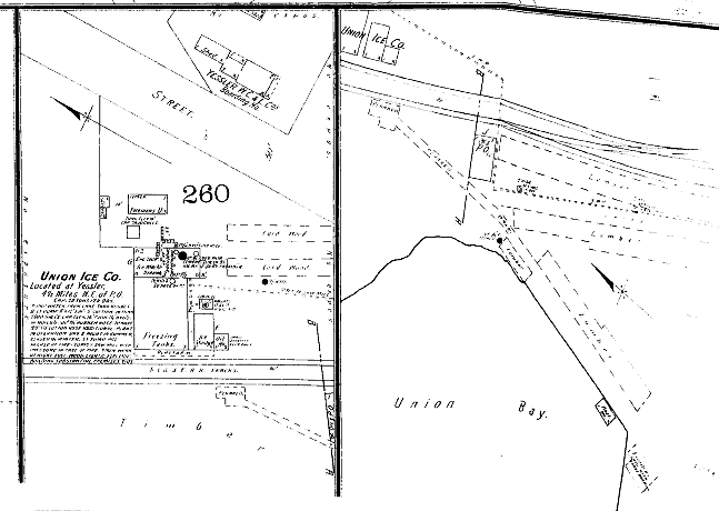
A section of the Sanborn Fire Insurance map for 1893, two years before the fire, shows several structures of the Union Ice Company, including freezing tanks, ice storage, and oil storage.


The Sanborn map provides intimate details of the workings of the ice company. It had the capacity to produce 20 tons of ice per day, pumping water directly from Lake Washington into 7500 gallon tanks, 16 feet tall. The plant was in operation day and night in summer; closed in the winter. Being a fire map, Sanborn goes on to tell us, somewhat prophetically, “The station pump [will] supply sawmill with pressure in case of fire.” The Sanborn notes conclude that the building is “substantial, premises tidy.” (Sanborn Fire Insurance Maps, Seattle, 1893, Vol. 2, Sheet 55a)

This small snippet of map may be the best depiction we have of the mill property in the few years it was active before the 1895 conflagration. The diagram also shows the route of the railroad spur, a “Yessler [sic] W. C. & L. Co. boarding hotel,” lumber runs, planked roadbeds, and a combination office and post office.

The lengthy article describing the fire in the P-I also gives a snapshot look at operations at the mill:

“[The mill] had a capacity of 75,000 feet in 12 hours and employs 36 men. It was a two-story structure with the sawmill on the upper floor and planing mill and engine room on the lower floor. It contained two double circular saws, an Allis edger, two large wood planers, a sticker, a shingle machine and a lath machine, a Corliss engine and a Noyle engine, two large boilers, an Allis steam setwork with twin engine…Of the 1,000,000 feet of lumber in the yard, only 15,000 to 20,000 was saved.

DECADES OF CHANGE


The years between 1895 and 1912 are somewhat hazy. All sources agree that at some point a shingle mill was constructed on the property that was the Yesler Mill. In her history of Laurelhurst, Christine Barrett reports that folks used to set their watches by the mill's noon and four o'clock whistles. 

One encounters the term “Yesler Mill” in newspaper articles and on maps as late as 1918. Whether the mill was operated by the Yesler Logging Company or an affiliate during this period is not clear. It is possible that the term “Yesler Mill” was just a comfortable moniker.

Beginning in 1912 the researcher finds references to a Two Lakes Mill which manufactured shingles at Yesler Station and maintained an office in the downtown Henry Building. Articles of Incorporation for the Two Lakes Mill were filed August 24, 1912. Newspaper ads include the following:

“Wanted: shingle bolts and stumpage near Lake Washington at once. Two Lakes Mill Co.” (1912)

“Wanted: to let contract for hauling several hundred cords shingle bolts, Two Lakes Mill Co.” (1913)

“Shingle your house all over with shingles made in Seattle. Inquire about our four grades and prices. Two Lakes Mill Co.” (1916)

The 1918 Polk City Directory contains a bolded listing for Two Lakes Mill: “Mnfrs of High Grade Premium Red Cedar Shingles.” However, the very next year the listing had been reduced to two words -- “wholesale shingles” -- perhaps indicating a downturn in the business.

Any doubt that we are talking about the same property where the Yesler Mill stood is laid to rest by an annotated diagram in the Sanborn Fire Insurance Map for 1919 showing the workings of “Union Bay Shingle Co./Two Lakes Mill Co’s Shingle Mill.” Notes on the diagram indicate that the mill had a capacity of 105,000 shingles in eight hours, that there was a night watchman, and that water was taken from Union Bay.


The question of corporate names does not die easily. In 1917, The University District Herald, under the headline “Yesler Mill Running,” reported “This mill has been idle for some time and it is indeed good to see the wheels turning again. It furnishes work for a bunch of men who are causing their earning to benefit Yesler in general.” (July 27, 1917) On April 25, 1918, The Seattle Daily Times reported that a shed had been destroyed by fire at the Yesler Mill Company plant, but that the mill itself was saved by the fire department.

The mill may have dodged this bullet in 1918, but most sources agree that the mill buildings succumbed to fire sometime in the 1920s. (Thompson, Barrett) There would be no rebuilding this time. It is likely that the cutting of the Lake Washington Ship Canal in 1916, and the subsequent lowering of Lake Washington, made it just that much harder to run a lumber mill of any kind.

As the lake waters receded, they left the mill wharf high and somewhat dry and the mill pond only slightly damp. At some point an attempt was made to dredge a channel into the bay in order to make the mill run viable again. This last ditch effort must have had only limited success because by the mid-1920s the mill was gone. Long-time resident Jim Thompson recalls watching the mill burn in 1928 or 1929.

While some lake mills may have benefited from access to the big steamers that the cut afforded, the Yesler Mill, on a shallow bay, was already too low in the water to make that leap. The mill's loss was the U Dub's gain. All the mill acreage, as well as most of the newly exposed wetlands at Union Bay, was acquired by the university with new uses in mind.


MEMORIES OF YOUTH


In 1971 not-yet-famous author Ivan Doig wrote a piece for The Seattle Daily Times based on the recollections of his neighbor in the area known as Exposition Heights overlooking University Village shopping center. Bill Lozott, Doig’s informant, recalls going down to the dredged mill channel to swim after a hard day’s work in the mid-1920s. 

In 2010, Jim Thompson, shared memories with the Friends of the Yesler Swamp and in 2016 spoke with this author. Both Lozott and Thompson recalled sawdust piles on the old mill site that would smoke and occasionally combust on hot days. Thompson remembers that the mill run “was dug deep enough to accommodate a tug;” he and his pals kept a very small sailboat, “the tar baby,” in the mill run.

My friend John found this old boat in the swamp. At that time they were building 43rd NE. Part of what they were doing to build it -- they had tar. So John and I went up and secured the tar, brought it down, melted it, and used it to caulk the boat somewhat. It was just a little throwaway. About a 10 or 14 foot little sailboat. So we went sailing. I was in my very best clothes -- and we tipped over! So I’m swimming in a brand new suit of woolen clothes.I had to throw them away, of course.

The dredged mill run can be clearly seen about center in this aerial from 1937. Even after the mill closed, neighbors attempted to keep the run open for boat launches. The channel eventually was abandoned to the encroaching wetland now known as Yesler Swamp. Image Courtesy University of Washington Special Collections.

***


Sources include:

  • Guy Reed Ramsey, Postmarked Washington: King County, 1966.
  • Christine Barrett, A History Of Laurelhurst, 1981.
  • Lucile McDonald, The Lake Washington Story, 1979.
  • The website of the Friends of Yesler Swamp. http://yeslerswamp.org/history/
  • Valerie Bunn's blogspot: https://wedgwoodinseattlehistory.com/author/valariebunn/.
  • Various articles from The Seattle Times, The Seattle Post-Intelligencer, and The University District Herald, including: Ivan Doig, “The home-town boy,” Seattle [Daily]Times, April 18, 1971.
  • Special Collections, University of Washington, including historic maps collection
  • Puget Sound Regional Branch, Washington State Archives, property and corporate records. 
  • Memories of Jim Thompson, courtesy of Friends of the Yesler Swamp, 2010, and as told to Eleanor Boba, 2016


-- Eleanor Boba, 2016